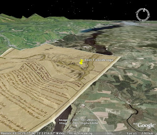
I'm learning more about Google Earth each day (It's on all the school Dells.). For one thing, it's very easy to add a historic map as an overlay. Find a map on the Internet and save it to your desktop. Zoom your view in Google Earth to the approximate view. Then select "Overlay" from the "Add" menu. Locate your map file in the browse box and add some info (image name and the URL where you found it). Tweek the yellow "handles" on your map to align it.
 Here is the same image of Fort Ticonderoga after I have added a historic map as a "layer." Once you get it oriented and scaled, it "drapes" over the elevations to give real dimension to the view! There is even a slider bar in the sidebar so that you can ghost the transparency of your overlay. Neat, yes? Ask me about the 1885 insurance map I have of Afton that layers over Google Earth to show you where all the hen houses and carriage barns were!
 Here is the same image of Fort Ticonderoga after I have added a historic map as a "layer." Once you get it oriented and scaled, it "drapes" over the elevations to give real dimension to the view! There is even a slider bar in the sidebar so that you can ghost the transparency of your overlay. Neat, yes? Ask me about the 1885 insurance map I have of Afton that layers over Google Earth to show you where all the hen houses and carriage barns were!


No comments:
Post a Comment